Monday, October 31, 2011
Moose Mountain Reservation
2 new reports for MMR! A porcupine, foliage and snow! Check them out HERE
Saturday, October 22, 2011
SPNHF Moose Mountain Hike 10/22/11
"A one-of-a-kind Pitch Pine Community" (pictures)
 Since Scott and I became volunteer land stewards for Moose Mountains Reservation in Middleton, NH we had only made the steep hike up to the pitch pine forest a couple times. We were spending all of our time on the lower trails and getting them blazed and trimmed first. And so, this Forest Society field trip sparked my interest and I had hoped to learn about it, including why exactly it is considered "one-of-a-kind in NH"! We hadn't been up to this area from the old Ski area yet and that is where the trip began.
 There was a large turn-out! I was rather surprised to see two dozen people bundled up in the windy, overcast morning ready to do some exploring. This trip was led by Forest Society's Mike Speltz along with some staff from Moose Mountains Regional Greenway's whom have worked closely with SPNHF on Moose Mountains. Today we would be viewing acreage that flanks the ski area and continues above it along the pitch pine hill tops covering several summit areas.
 The purpose; to get public support for the purchase/easement of this property which would add 500 acres to Moose Mountains Reservation's which already sits at 2300! This would also permanently protect this rare pitch pine community. *Picture to left: The proposed property is in RED. It flanks the Moose Mountain Recreation area and includes all of the property from half-way up the old ski lift and up to the Moose Mountains Reservation property. The trails we used are marked in YELLOW.
 The trip began at 10am. As the land stewards for MMR we wanted to join this trip so we could help out in any way we could and so we could lend any knowledge we had obtained of the property in our short 5 months of exploring it. We set out for the left side of the ski area (Moose Mountain Recreation) and headed up an old skid road which I believe was also a ski trail when it was in operation. Mike took the lead while we kept the rear of the group with an MMRG lady (whose name I can't recall...sorry!) The hike was steep as it climbed nearly 800 feet in about a mile! Along the way Mike introduced us to the group and let them know some of what we do and to chat with us if they wanted to learn more. He also talked about the different hardwood and pine tree's as we got more and more glances of colorful views as we climbed.
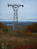 When we arrived at the flat area at the top of the ski area we gathered around the old ski lift and looked out at the wonderful view of foliage. Wentworth and Kingswood lakes were in view. We could also see Chocorua, which seemed to be hogging the sunlight all day as it's rocky summit and ledgy ridges glowed against the cloudy sky's. To the left the Sandwich range was in view as well as the Ossipee range. To the right, Carter notch was barely visible.
 After a short break we continued the hike over more easier elevation and finally emerged into the "rocky-ridge pitch pine forest". The bright red and orange blueberry bushes were a sharp contrast to the gray ledge and scruffy barked green pines. Mike stopped to tell us about this area. Namely that the pitch pine should not be growing here. It is one-of-a-kind in NH that a pitch pine forest of this size is growing at such relatively low elevation.
 At the 3 way intersection at the height-of-land we went right and followed the road to a flat shelf-like ledge. Scott and I had been in this area before! Mike led a bush-whack down further and onto another ledge area. Here we stopped and had our lunch. Mike talked more about the forest we were in and we enjoyed some laughs and small talk. Once lunch was done I asked if Mike new there was a road just through the woods that leads down to the South side into the reservation. There is more pitch pine and a nice view not far that I wanted the group to see. He told us to lead the way!
 We made a short whack to the road and out into a ledgy area with partial views. I informed the group that the road we were on connects down to the reservation and let everyone know about my MMR blog in hopes to get more people interested and hiking in the reservation. After some talking and photo shots we headed up the road. Back at the three way intersection the group stopped ahead. I figured Mike new where he was going or at least recognized this junction but he began to head left. He looked down at us and I signaled right. We all got a good laugh out of it!
 The trip down was a bit tricky with the steep, loose and wet rock but we descended quickly. Back at the ski lift Mike decided we'd try the other ski trail on the opposite side of the ski area. And so we descended down the steep trail. We had two guys (from what I saw) slip on the way down, but nothing major. We all arrived back down at the parking lot from what was an enjoyable hike and not to bad of a day for weather. Could have been better, but could have been worse too. At least we had some views and it didn't rain! And we got to talk with friends we had already met at MMR and got to talk with others interested in what a volunteer land steward does.
 Since Scott and I became volunteer land stewards for Moose Mountains Reservation in Middleton, NH we had only made the steep hike up to the pitch pine forest a couple times. We were spending all of our time on the lower trails and getting them blazed and trimmed first. And so, this Forest Society field trip sparked my interest and I had hoped to learn about it, including why exactly it is considered "one-of-a-kind in NH"! We hadn't been up to this area from the old Ski area yet and that is where the trip began.


Monday, October 17, 2011

Monday, October 10, 2011
North Moat via Red Ridge 10/9/11

What a GORGEOUS day!! Not wanting to waste any second of the day we quickly decided Sunday morning where to head. When we got into Conway it was decided, a loop on the Moat mountains! We had been wanting to hike this for a long time now and today was the perfect day for it! We parked at the large parking lot for Diana's Baths. We quickly got our packs on and headed out at just before 8am.


Subscribe to:
Posts (Atom)