"9/11 10nth Anniversary FOT48 Hike" (
pictures)
Year three of being involved with "
Flags on the 48" and the 10nth Anniversary of 9/11. This year I chose Mt. Willey because we enjoyed the view from the lower ledge so much the year before. This year we actually had a good size group. Me, Scott, my sister Jill and her husband Rob, and two people from Rhode Island we had met on an earlier hike on Moosilauke, Caleb and Jonathan. Driving would be a little longer as we had to take I93 and access 302 through Crawford Notch due to the road being washed out on the lower portion from Hurricane Irene's flooding rains. As we entered the notch just past the Highland Center the road was half blocked and read "Local Traffic Only". I was a little nervous I wouldn't get past the construction worker standing guard. I said to the others, "what kind of local traffic do they get in the notch? It's a freekin' national forest...no houses, no business', just forest! LOL" So I drove past the blockade without so much as a glance from the man in orange! Phew! Signs of washout on this steep hill where two steep rivers cross beneath the road were very visible. Water had washed out the ditch along the roadway.

We arrived at the Kedron Flume trail parking lot at the Willey House site right on time at 8:30am. Caleb and Jonathan pulled up shortly after....or they were already there waiting for us....I don't recall. We all introduced each other, divided up the flag parts and headed on our mission. It was a little cool out but very comfortable hiking temperatures. Jill was very excited to be on a big hike as it had been 10 or so years since she had been on a 4000 footer! Rob was also happy to be on the trail and we were all in very good spirits. We made a quick ascent on the long, gradual switchbacks to the train track and made the short, steep climb up the banking above the tracks.

A few more switchbacks and we entered the pine forest and soon made the short descent to Kedron Flume. Here we took a break and chatted and took pictures. It was looking like a beautiful day! A little hazy, but was looking promising for some clearing and sunshine! We now made the steep climb up the banking and through a heavily damaged forest. This area always looks like it takes a beating from wind but is always cleaned up by the trail adopter. We hiked at a good pace. Caleb and Jonathan had the lead and are more faster than the rest of us. Scott and I were a little behind them and Jill and Rob took the back. This actually kept a nice, but not overly exhausting pace.

We arrived at the Ethan Pond trail and followed this level section to the Willey Range trail. Here, I told Jill and Rob, is where things get steep and interesting! After crossing a couple small streams we began the climb. First up loose, steep gravel then up a set of stairs. Soon enough we arrived at the oh, so awesome ladders! I remember them being steep and many, but forgot just what it was like. You climb several sets and as you climb near the upper section you are greeted with more! Such a fun part of this trail! At the top a nice view down the Southern portion of Crawford Notch was visible as was the stand out shape (
roche moutonnee) Mt. Crawford itself! Jill made the top of the ladder's looking pretty tired. She was doing so good for having a baby 3 months earlier and on the recovery from a bronchitis infection!

The climb continued steeply over a rocky trail and here a couple gray jays made an appearance. I had hoped they would be out today! Scott and I had such a good time our last visit feeding the jays. Rob managed to feed them some sun flower seeds and then they left. After more climbing we finally reached the ledge outlook. We checked the view real quick...a fabulous view across the notch to Mt. Webster's slide and rock scarred ridge and up to the Presidential's. Mt. Washington was in the clouds, but looked like it may clear within a couple hours. We made the short climb to the forested summit and unpacked the flag and pole sections. The time was 11:30am. WOW! We made the hike at the book time! Way to go Jill!! It was now that I went into "Boss" mode! Growing up in a self employed family I have always been in charge of people. And, well, when I get in the"zone" I direct well and I focus all my concentration on the task at hand. This must have been visible as my sister and Scott kept poking fun at me as I tried to set things up as perfect as I could get them.

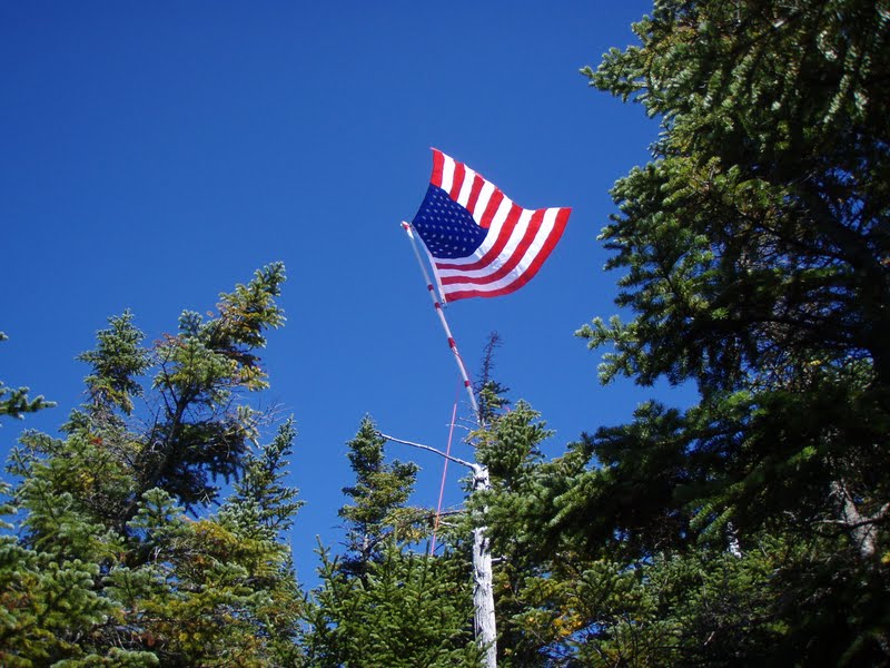
This year was a little different. I had a second flag added on, the "
Flag of Honor". Also, in the two prior years we were dealing with summits which had 15 foot trees, all I had to do was climb and tape the pole to a tree. This peak had trees about 10 feet high. First the pole had too much slack. So I climbed a small tree and tied the pole to it. Then Rob and I fastened the ropes to trees to stabilize the pole. As we left the area I noticed a rope had come undone so I was back in the trees switching ropes around and trying to insure the pole would not fall or snap at a junction point. The wind was blowing really good and in different direction so it was tough getting the strings pulled at just the right angles. Scott came back to see where I had disappeared too and helped me out. Once satisfied, the flags flying high and beautifully against the blue sky, we returned to the ledge with the others.

We ate our lunch for half and hour or so. Unfortunately the Gray Jays were not around. However, while eating our lunch I heard a chopping sound in the distance. It sounded like a helicopter. Sure enough I could make out a chopper headed in our direction from Mt. Carrigain. We all watched as a National Guard Black Hawk Helicopter came just a 100 feet from the mountain side and climbed the slope and hovered over the summit taking pictures. How awesome! That chopper visit made the day so much more memorable and exciting! Later I checked the FOT48 facebook and websites to find that no one new the chopper was going to be doing this. They got as many peaks as they could, some where clouded in unfortunately. Pictures (by David Breton) taken by the chopper can be found on Facebook
HERE.
Shortly after our lunch Caleb and Jonathan decided to head back down as they had a long drive home. So we all went back to the summit and took a group photo. They headed down and we hung out on the ledge, relaxing in the sun and taking in the view. With my binoculars I could see flags on 2 peaks, Mt. Carrigain and Mt. Monroe. I could see people on Jackson and Eisenhower but was not able to make out the flag on either. Our solitude was then broken by 3 dogs that came running out onto the ledge and all over our bags and us. Ugh! There's nothing I hate more than dogs on the trail that are not at there owners side or leashed! The group of hikers had come over from Field. They had set the flag up and decided to "tag" Willey. Many others also showed up also "tagging" the 3 mountains on the range.

It was getting a little crowded on this little ledge so we decided to pack up and do a little trail exploring and let the others enjoy the ledge a little. So we headed over the summit and down the other side to a small outlook. Then we went down the trail a little ways before deciding to turn back. As we passed back over the summit again the group was heading back to Field. We headed back to the ledge and set up shop on the far side. We still had 45 minutes until the flag had to be taken down. So we just chilled out on the ledge. Shortly after, yet another dog came trudging all over us. Another group showed up behind the dog and I asked them to call there dog. I got a couple dirty looks and they called the dog away. Excuse me for being allergic to dogs and for all of us not wanting a smelly, drooling dog walking all over our bags and food. Grrrr....I HATE inconsiderate dog owners >:(

2:00pm rolled around and we began to pack our bags. Just then Wendy found us! Wendy is the a Forester with the
Forest Society. We are the
Moose Mountains Reservation volunteer land stewards for them. She was camping with the AMC and had told us she may come up the mountain to visit us. And here she was! She had bypassed the ledge outlook a little earlier and figured we were out at the other peaks. So she ate lunch on the other side with some lady's. She happened to check this ledge and found us! It was so exciting and awesome that she came to see us and our flag! Once the rest of her group arrived we took pictures and watched the flag make it's final flaps-in-the-wind. Then we all took it down and put all the parts away. We said our goodbyes and headed down. The steep hike down was a little slow going. We all had tired legs and were taking it easy on the moist trail.

Back just above the flume we stopped at a little fern gully where a section of earth is washed away. The banking forms a thick mud wall where ferns grow on top of and water drips down onto a flat rock. It's a pretty neat spot. Anyway, the mud that looks like rock had Jill's interest. I told her it was mud and I stepped up the wet rock and touched it. Wanting to touch it too Jill began to climb the rock and lost traction and slipped! She landed butt down onto the wet rock! Eeek, LOL! Her husband quipped, "you just had to touch the mud didn't you? Now you have a wet ass!" We all had a good laugh over it! We made the rest of the hike down over the gentle switchbacks and arrived back at the truck at 4:30pm. A fabulous day and a great crew. Thanks to all who participated in Flags on the 48 and flew the stars and stripes on NH's highest mountains for all those affected by and lost on 9/11/01!


 It was at the East Peak and all the way to the Main peak and back that almost every hiker asked if we had come up from the Kanc' side. Each time we answered yes the reply was always....isn't that side steeper? Our answer...it was very steep! It was really funny how many people asked, and their reaction to us taking the more difficult side up. But that is how we generally roll! The longer, steeper, less used trails are usually quiter and more exciting. Which is what we hike for! Too many times (including today) we see hikers just rushing on by to get to the top and "bag" a mountain. I just don't see the point or excitement in this. We hike to enjoy every aspect of the trails. To enjoy the natural beauty around us.