Showing posts with label "4000 Footers". Show all posts

Tuesday, September 6, 2011

2011 FlagsOnThe 48 - Mt. Willey

This year the HikeTheSummits group will be climbing Mt. Willey on 9/11/11 for Flags on the 48! This Sunday Americans will remember this day each in there own way. We will be climbing a mountain and raising a flag on it's summit along with 47 other groups climbing the other 4000 footers in the White Mountains! If you still want to join us it's not too late! Click on this LINK to the Event page for more info!

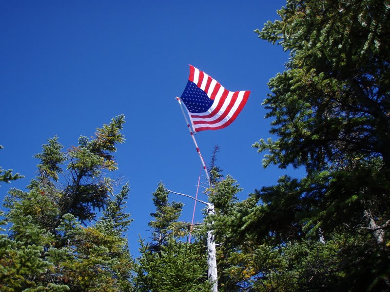
This year we will be adding a new flag to fly as seen in the picture. The "9/11 Flag of Honor" is created with the names of all who perished on the 9/11 attacks and honors our fallen Emergency Services Personnel in red and blue. Thank you to Mainely Flags in Portsmouth, NH for having these flags, what a great and friendly store! Good luck and safe hiking to all the 2011 FOT48 groups!

Tuesday, August 16, 2011

Mt. Garfield 8/13/11

"Number 26 and Two to Go!" (pictures)

The weather was looking good for Saturday so in the morning we headed for Garfield. I had only done this peak once during one of my fathers Youth Group hikes in 1998. So this was like hiking it for the first time as I didn't remember much. The Galehead Road was fitted with brand new bridges, they even smelled new! The parking lot had a van and a couple cars with fog on the windows, indicating they were over-nighters at the hut. We got a really early start at 7:45am, with a couple people starting right behind us.

The trail climbs a banking and meanders through a pine forest. I spotted a couple Downy Rattlesnake Orchids along the trail here. We heard a group of girls singing through the trees and soon a girl scout or girls group came marching down the trail of about a dozen. Most had smiles on there faces and it looked like they had a great time! The group leader at the rear of the line apologized for there "intrusion" and once past us we could hear her yelling up at the front of the line that they had best stop for hikers coming up the trail! 

We were passed by the others that started out behind us and we soon left the pine forest and into a wet section of forest. The trail adopter has really done a lot of work in this section building all sorts of water bridges/platforms and foot bridges. Great job! The trail now climbs at a moderate grade following a fire road. Remnants of the power line poles are seen off the trail if you look hard enough. Mushrooms were out and as usual we were stopping constantly to snap pictures of them! Once the trail began a steeper climb and mushrooms became less, we picked up our pace.

The trail makes some long switchbacks and Indian Pipe were flowering all over the place on the upper sections. White and yellow Aster were also flowering along the trail. After negotiating the switchbacks we made one steep climb up next to an interesting rock formation. We finally reached the trail junction with Garfield Ridge trail after what seemed like a long and rather boring climb of 4.8 miles. Now, as the trail book indicated, the trail makes a sudden steep climb up to the rock spire summit of Garfield.

There was almost a dozen hikers up top. The rather unfortunate thing about this summit is that the cement foundation walls are left at the top. This takes up too much room and is an eye-sore in our opinion. It should have been completely removed! We climbed down the ledges that drop in layers on the South side. We found a nice ledge to eat lunch on away from the crowd. Arrival time was 11:15. Wow! a half hour quicker than the book time!!

We took our time eating our lunch and enjoying the beautiful day. The humidity was causing hazy conditions so views weren't the greatest. The Twins and Franconia range were in view, The Franconia's in particular were impressive with the towering summits of Lafayette and Lincoln followed by the pyramid spires of Liberty and Flume. Owls Head in the middle of the valley floor was also impressive from this vantage point above. The Bonds were barely visible through the haze as was Carrigain and the Sandwich Range.

Our lunch consumed and our bodies rested we packed up and headed back down. We passed a lot of people making there way up the trail. So glad we have been making the early starts and beating the crowds! When we arrived at the parking lot 30 or so cars were parked up and down the road! Number 26 of the four thousand footers for Scott. Two to go to catch up to me! Then we can finish the rest at the same time :)

Monday, July 18, 2011

Mt. Cannon 7/16/11

"A Switch-backin', Pine Bramble" (pictures)

With beautiful weather on tap for the weekend we had our eyes set on a 4000 footer! We planned on doing a peak to get Scott caught up to me. Thus the options were Garfield, Tecumseh, Cannon and Eisenhower. Tecumseh is an easy hike I'd like to save for winter so that one was out. Eisenhower I feared would be very busy as it generally is in the summer. Not to mention the trails to the summit aren't the most exciting. Next on the list, Cannon. Again a very busy mountain particularly with the gondola. But, one that I hadn't been to in over 10 years and it had several trail options. Garfield is one I have been really wanting to hike too. I haven't been on this mountain in close to 15 years! We planned on getting up really early so I waited to see how early we managed to head out, how we felt and how the weather was in the morning to determine the mountain.

We awoke early as planned and headed out the door feeling ready and excited for a great day of hiking! Cannon was our pick for the day. Perhaps with the early start time and with the races going on in Loudon perhaps it would be on the quite side. We arrived at the trail head and got front row parking at the hiker parking lot! Awesome! I mentioned to Scott this lot will be overflowing out to the road when we get back! We got our boots on trail at 7:30am. The trail cuts through the campground, people were just getting up and getting there breakfast going and what-not. Once past this the trail climbs a wide gravel path up to the junction for Lonesome Lake trail. We took a right here on Hi-Cannon Trail.

The trail now climbs moderately up eroded switchbacks, passing various boulders. Many large/mature birch trees grace this hillside. Scott spotted a large toad in the sandy trail and Northern Wood Sorrel was blooming here-and-there. We stopped at a fallen down tree that had it's entire root system pulled halfway out of the ground looking like bars in a prison. Mushrooms were plentiful and the day was starting off very pleasant!

Past the Dodge Cutoff the trail climbs more steeply and the trail seems to become less eroded. It would appear hikers stick to the trails to Lonesome Lake and probably ascend Cannon via Lonesome Lake trail. After a couple large switchbacks you then must climb a rather rickety ladder along-side a steep ledge face. We've been on plenty of ladders in the Whites, many steeper and higher than this one, but something about it leaning to one side and the steps looking a little worn made this climb a little creepy!

Continuing on the trail follows the crown of the ridge with views across the notch to the Lafayette Range. Then you arrive at the first of several fine ledges. We sat down on this ledge and took a nice long break enjoying this fine day and beautiful view. From the left you could see the Eagle Cliffs, the impressive Lafayette/Lincoln peaks and down to Mt. Flume. The view continues across the notch and around to Lonesome Lake. After some time we were joined by a young couple and we packed up and got back to the trail. The pine trees along this section had grown in and were brushing up and poking at us as we passed through. We checked out two other ledges along the way, with the added view to the Kinsman Mountains.

The trail moderates some as you pass through and over several ledges and rock formations.We soon arrived on the Kinsman Ridge trail and made the easy climb to the observation tower on Cannon's summit. Number 25 for Scott, still 28 for me! The summit was still surprisingly quite, but it was only 10:30am! Perfect time to be up here! We took our break and took in the view. Not all that better of a view than from the ledges, but a 360 degree view none-the-less. We then headed down and explored the rim trail a bit. We discussed hiking down to the profile clearing but it was much further than we wanted to go and snooty city folk were beginning to clog the summit trails. So we decided to head back down.

On the way down from the summit we passed a couple dressed for a walk in the park, the man carrying a small business type bag slung over his shoulder. They were having a hard time negotiating the rocks and I wondered were the hell they thought they were going. Were they trying to hike down to the pond?? Some people just don't realize that 2 miles on a street is not the same as in the mountains. There's elevation, rocks, loose footing, etc. Ah, well! Perhaps they would figure that out before they got themselves into a mess!

We climbed down quickly to the ledges and took another break here. Then we hustled down and carefully descended the ladder and the loose, eroded switchbacks. We arrived back at the campground, snickering at the campers sitting in there cars at the campsite and one lady who had her lawn chair plopped down in the parking lot reading a book. Ummm, OK! Looks like fun, LOL! The parking lot was as I figured it would be, full and overflowing to the street side. We finished our hike at 12:45pm. A great hike with lovely views and ledges. The first mile is eroded and not the best footing. But get past this and the trail turns into a pleasant hike. This trail really needs some attention; erosion, overgrowth, faded blazes, and worn/faded/broken signage plague this trail.

Monday, May 30, 2011

Mt. Moosilauke 5/29/11

"Fogged in on the Moose!" (pictures)

Difficulty: Very Hard/Expert (wet, slippery, steep trail with ledge climbing and steep drop offs)

Stats (round trip): Mileage> 7.6 - Elevation Gain> 3100' - Book Time> 6:50 hrs - Our Time> 7 hrs.

Directions: From I93 in Lincoln, NH take exit 32. Head West on Rt. 112 continuing straight through intersection for Lost River. After passing lost river at about 6.3 miles the trail head will be on your left on a corner. Signs are present.

Report: With the long Holiday weekend upon us and Saturday looking like it would be a nice day we set our sights on a 4000 footer. I had some peaks in mind and when Scott said "how about Moosilauke?" I quickly agreed! Our last and first summit of 'The Moose' was when we did Beaver Brook Trail in September of 2007, our first year hiking together. And we were anxious to hike this beautiful, steep and rugged part of the Appalachian Trail again! As we arrived in Lincoln the clouds were still hanging onto the peaks and valley's but it looked like it would lift and break by noon.

We parked in an already 1/2 full parking lot, some overnighters no doubt and some day hikers. We started out at 8:30am. The trail along this portion was full of Hobblebush, Bluebead Lily's, Sissile Bellwort, Rose Twisted-stalk and mostly spent Trillium. We signed in at the warning sign reading "This trail is extremely tough. If you lack experience please use another trail. Take special care at the cascades to avoid tragic results." Those types of signs always excite me!

Soon we arrived at Beaver Brook and the 3/4 miles start of nearly continuous cascades! The trail follows the river over steep ledges fitted with steps and re-bar for pulling yourself up. You climb up wet, slippery, broken rock and along side the steep and dangerous brook banking where a slip could be your doom! I could not imagine the campers and through-hikers carrying heavy packs down this trail! It must be so tough!

Still climbing up the steep trail there is plenty of moss and lichen that add to the beauty of this trail. I found some crustose lichen flowering which is not something I had ever seen before. We found a few mushrooms also. Cascades continued, the waters were flowing nicely and it was such a beautiful day. It was getting warm and muggy and it was rather a relief to not have the sun shining down! We stopped and posed for pictures along this exciting trail and amazing world of falling water.

It's one of those areas you could spend all day in taking pictures and taking in the scenery. But just a reminder, extreme caution should be used on this trails and along the bankings which are steep and dangerous. One simple slip and you could be falling down a steep cascade of jagged rock and fast moving water to your death!

Finally we veered away from the brook and passed the trail for the cabin. We started to see people now climbing past us from the cabin and a few descending back to the cabin. Soon we arrived at the Asquam Ridge Trail junction where we straightened out the sign post by wedging in some rocks. From here the trail began to climb rock as it curved around Mt. Blue. There were view spots here and there but the fog was still so thick you could not see beyond a few pine trees.
After climbing for a bit the trail leveled off at a muddy section of trail then began to descend gradually along a ridge. I remembered following a ridge for a short way but did not remember descending and especially not this much. Soon I told Scott it just didn't feel right and I think we missed a trail junction or something. It didn't help that I forgot my map and that I couldn't see anything to get my bearings and it was driving me nuts! Scott reassured me that we were most likely on the trail, that I probably just didn't remember this section. And the fact that people we passed earlier were mentioning the fogged in summit. So this had to be the right way!

Continuing along the muddy ridge we finally got a quick glimpse of Moosilauke's summit cone. YAY! The trail began to climb again and once passing through some washed out sections of trail we passed the Benton trail junction and began to pass people coming down who looked wet and wind blown! A couple hikers told us it was very windy up there. We finally broke tree line at 12:30pm and were greeted with a misty wind blowing at a steady 40mph. It was a mild wind and a welcomed refreshment from the muggy lower portions of the mountain. The sky would light up a little now and then, and a tiny patch of blue/clear sky would open briefly giving a short range view. And like a hiker said, "oh look a view, and poof, there it goes!"

Ah well, as 1HappyHiker commented, sometimes the foggy conditions are just as exciting and interesting! And no one was really complaining, most were enjoying the moment. Not even a group of three from Rhode Island and North Carolina where too bothered by no view. They enjoyed the hike up Beaver Brook so much and rather enjoyed the wind and fog! As we approached the true summit, figures began to appear and as usual the summit area was crowded with a dozen or so hikers. Already having this peak we decided to turn back around a have lunch at the tree line where the wind was lighter.

Sitting there for this short time was so nice. Such a calming atmosphere and no pesky bugs to swish away. Actually there had been no bugs at all, all day! That always makes for a great hike! Once we had our fill we headed back down. We met the group of three again along the shoulder of Mt. Blue and we chatted for a bit. They were a very friendly group! We parted ways and made our usual quick descent, slowing as we began the steep and wet hike down along the brook. Below the cabin we began to pass hikers headed up to the cabin. And now the views began to open up a little better!

Along the trail we spotted a couple Northern/Red Spotted Newts which I moved off trail. Back below the cascades and on level ground, ahhhh, we took notice of the wildflowers again and noticed yellow flowers had since come out which were Trout Lily's. So many neat little wildflowers in this moist woods! We finally dragged our weak and tired legs across the last foot bridge and up to the parking lot, finishing at 3:30pm.
Monday, September 13, 2010

FOT48 Passaconaway 9/11/10

Flags on the 48, Saturday September 11, 2010.
Pics HERE

We arrived bright and early at Ferncroft parking lot just after 6am. A van was there and a car pulled in just before us. Scott's first FOT48 hike and my mom made a day-before decision to come along, her and I on our second year. We geared up and headed to Old Mast Rd. The two who had pulled up before us asked if we were with FOT48 for Passaconaway. I said yes rather surprised, as I wasn't aware of anyone signing up. They (Andy and Jess) said they had a day or two ago and that they had sent me (or someone?) an e-mail. I kinda started things off rude by telling them my mother hated dogs (as they had one with them). Probably not the best thing to say to strangers who would be joining us, but I just wanted to ensure my mother's and my enjoyment of the hike without a loud, out-of-control dog. The dog, Skyler turned out to be very well behaved however so it all worked out fine. Sorry for the rude introduction!

Off we went taking the Kelly trail. I knew this would be a bit more ambitious than some of the other, easier routes to the summit but I wanted to make a day of it and explore a new trail that I have been wanting to hike. Kelly trail was well maintained and we kept a very good pace, stopping shortly now and then for a quick swig of water. Jess had done two hikes up Katahdin this year and Andy from what I gathered  has not done a whole lot of hiking and was asking plenty of questions and seemed to be really enjoying the hike. The trail stayed rather gradual and got interesting at Paugus Pass where the trail climbs through a narrow gully similar to Ice Gulch, but lacking the boulder filled floor. Layers of rock shelves formed walls on either side of us. My mother got her hair bun caught in branches twice. And Scott and I forgetting we had poles rising over us, got caught a couple times on branches and a couple of head height blowdowns. So we a few good laughs! Then at another point my mom and I bent over to look at a moth on a birch tree bringing my flag poles in contact with her head. It was a pretty hard hit, but no blood thank God! We arrived at the Square Ledge Branch trail where we took a break. The SLB trail makes a steady climb up to Square Ledge trail where you climb steeply, with views ahead through the trees of Square Ledge. The trail brings you just below the ledge, then swings right of it and climbs beside it and through a stone trough of sorts. Once above and just past this a view spot on a steep ledge is on the right overlooking the large mass of Mt. Paugus. We took another break here.

The trail now drops to a col then climbs steeply up to the Passaconaway Cutoff trail. Here we met 3 guys who started from the Kancamagus Highway carrying a flag that had hung over the US Embassy in Afghanistan. We chatted shortly then began climbing down dropping to another col. passing a view spot to Whiteface. Then we steeply climbed to the base of Passaconway's cone. A final steep push up Walden trail brought us to a level area. The trail swung around right and past a large flat rock with views towards Chocorua and North to Washington. There was a group of 5 with large camping packs on the rock, so we continued on as we wanted to get the flag up anyway and find the North View spot for lunch.

We passed the North view sign and soon found the summit sign to our left, right on time at 11:45am. We began assembly and I decided to scale a tree this year as I had done the year before on North Tripyramid. After several attempts to secure the pole to the tree, we finally had it set in place and secured. Unfortunately there was very little wind up here. But now and then a small wisp of wind would bring the flag at attention. Several people were there taking pics including the group we had met earlier who opened there flag for a picture, then headed back down before I even had a chance to see it and take a picture. We now made our way to the North view spur path which climbs down annoyingly, .3 miles and 200 feet to what turned out to be a small ledge where the group of campers had migrated to. We unpacked our lunch and huddled along the trail to eat, and once the group headed back up at about 1:00, we took possession of the space to take in the glorious view.

The view was spectacular. The entire White Mountain National Forest opened up in front of us! Cloud covered Mt. Washington in the middle, flanked on the left by the southern Presidentials, the Pemi Wilderness, Franconia Notch, the Hancocks, a spectacular view of Carrigain and it's notch, the Dry River Wilderness, the Osceola's and the Tripyramids. And to the right, ledgy Hedgehog Mtn. directly below, the Moats, Chocorua, Kearsarge North, Wildcat, Carter Dome and the Baldfaces. One of the best sweeping view spots I think I have seen!

About 1:30pm we headed back up the trail and decided to drop our bags at the view spot to the West of the summit overlooking the Tripyramids. I took off to snap pics of the flag and over the the East view spot we had passed earlier. Then we began dis assembly of the flag. We began our decent at 2:00pm. The first section was very steep. Jess slipped on a rock catching herself from falling. Then I did the same thing on the same spot, twisting my ankle to the point of pain and burning. Very thankful that it didn't sprain or fracture! Must be all the hiking this year keeping my joints flexible. The burning feeling went away after about 10 minutes and no pain, phew! We were clearly a bit tired and this steep section was getting the best of us. On another steep section my mother made a wail and I turned back to see her crash to her knees and into the pine trees! This can't have a good outcome! But once again someone was watching out for us, my mother's knees landed on a bed of thick moss! She walked away from this wipe out with a small scrape on her arm from landing in the trees. Another catastrophe averted we got moving again.

Jess and Andy took off down the trail at this point to meet us back down at the bottom. We slowly made our way to the switchbacks where the trail eased and stays at a gentle grade down Dicey's Mill trail to the Ferncroft road and parking lot. We passed a few people thanking us for our efforts and passed many making a late ascent. Onto Ferncroft road and past the picturesque homes, we arrived back at the parking lot at 4:30pm and very happy to get the boots off and throw a fresh shirt on! We said our farewells to Jess and Andy and headed out. A great day, perfect visibility, temperatures and trails. Couldn't have asked for a better day.
Thanks to all who participated in FOT48, God Bless America, may Freedom ring from mountain top to mountain top!

Trip Totals:
Mileage - 11.5 miles
Elevation Gain - about 4,520 feet
Time - 10 hours

Pics HERE

Monday, August 9, 2010

Moriah and Shelburne Moriah Mts. 8/7/10

View Pics HERE

"MUDing and PUDing, a Kenduskeag Scalping!"

We parked at the Wild River campground ready for another long Saturday hike. Shelburne-Moriah and Moriah Mountains were the objectives today and the crisp, dry air were just what we had hoped for! We left the parking lot at 8:00am and walked back down the road to take Shelburne trail from it's start. Though the water level was relatively low the crossing proved difficult. We had to go upstream a ways to find a good crossing. Once across, a dried up river bed tempted me to take that to High Water trail that follows the river. We came to a stream instead of a trail. So I pulled out my map and found that the trail is actually further away from the Wild River in this area than I had thought. First of two mistakes made and not wanting to take a chance on following the stream and not finding the trail, we back tracked back to and down the Wild River to the Kenduskeag trail and began our long journey.

We crossed several dry river beds and flowing streams, climbed a banking and passed the High Water trail junctions. From here the trail is rather boring. Mushroom hunting helped to pass the time. The trail is very gradual and overgrown in many sections. I stopped to clear a blowdown about a mile in. Otherwise, the blowdowns were taken care of, just some shrub growth beginning to take over the little used trail. Once you reach the brook crossing (approximately 1700ft.), the trail climbs steeply. Along our steep climb we could here some birds chirping. I was startled when I heard Scott ahead let out a scared yelp. I looked up in time to see a goss hawk nearly a foot away from scalping Scott. His yell scared it back and it flew around me and onto a branch 15 ft. away. It glared at us then flew off out of sight. Apparently that chirping was a nearby nest! We cautiously made our way out of that area, not waiting for it to come back out of the trees for another attack!

Neary 4 miles and 1700 feet of elevation behind us we finally arrived at the Kenduskeag trail. The steep climb continued before leveling off under some ledges then a ledge on the left that we could climb to get our first views of the day. Shelburne-Moriah Mt. rose steeply ahead of us. Moriah could be seen as well as most of the Carter's and the Baldface's. We returned to the trail, dropped slightly then climbed through brush and a bad washout at a ladder and up to an open knob with more views. A board walk started here which helped through the muddy sections. Down another col. than another steep climb up Shelburne Mt. We climbed out of the tree's to an open plateau, then back into trees and onto boardwalks and mud to the Western, more open side of the mountain and it's highest point.

We reached Shelburn-Moriah's summit 3735' at 12:15pm. Picture taken we hit the trail again, the semi-open ridge and Mt. Moriah ahead of us, with the Northern Presidentials now looming behind Moriah. We climbed down the summit to the ridge and found a spot with a little less wind. Temps. were only in the mid-50's and the wind hitting our sweaty bodies was a bit cold when not moving. Lunch quickly eaten we continued on our journey. Kenduskeag is the Abenaki word meaning 'pleasant walk', but it was anything but. The views from the Western side were nice. Particularly the unique view across to the Baldfaces, the granite bald shoulder of South peak shining in the sun. And the view of Moriah from this direction interesting, especially of the granite slide on Moriah's North East facing slope. And I never seen such an extensive sections of boardwalks. They must be over a mile in total length!

From here pretty much the same story the rest of the way to Moriah's summit. PUDS, Mud, boardwalks, back into trees and then steep, steep, steep. Once passed the Rattle River trail we began to see people as I had predicted. One impartcular gave us a good laugh. Scott stopped because he had heard a noise. A small dog came around the corner and began yipping. The owner yelled "shut up Jake!". He stated the dog owners usual words "he's OK" to us, then picked it by the handle of the dogs pack and carried him by us. It was rather humorous. We had just about ran out of energy when we finally made it to the summit sign and reached the surprisingly empty summit 4049' at 2:15pm. We snapped some pics, had a snack and took back off, many more miles to go and the day getting late.

It was at this time I made mistake number 2 of the day. When coming down off the summit, I took a left at the carter-moriah trail sign. We dropped nearly 200 feet before I had a feeling that something wasn't right. We should not have dropped this quickly and there were no open ledges I remember from our hike in 2007. And I was certain the trail we took up our last Moriah hike over Mt. Surprise was Carter-Moriah trail. So I once again took the map out, and lo and behold we were headed the wrong way, rrrrr! We angrily trudged back up the steep trail, passing those we saw going up, who looked at us confused. Wiped out now, we arrived back to the summit sign. As we passed it a hiker said, "aren't you going to the summit? It's that way!" We said we were already there but went down the wrong way. He laughed and said "that happens", he himself had gone right by the summit sign and that is why he was making sure to point it out to us.

We climbed down the steep section back to the kenduskeag junction and continued on the Carter-Moriah trail. Passed by many other people, again expected on this portion of the mountain, and as we arrived at the ledges we looked back at the now visible summit full of people. The rest of the trip went well. 5 long miles of Moriah Brook trail, but this trail is always a pleasure. Easy, soft footing most of the way and a beautiful, cascading Moriah brook. The water was low so the cascades along the way weren't much and since it was getting late in the day I didn't make many stops or side trips for pictures. We hussled down, making our way to the gorge and the PUD section of trail up and down small run-off stream gully's. Finally over the bridge and a final climb up a banking. We reached home plate at 6:00pm.

Total trip time 10hrs.; 15 miles; 2800 ft. elevation; weather-perfect! NO BUGS !!!! : )

Pics HERE

Monday, August 2, 2010

Great Gulf (Mt. Washington) 7/31/10

View the pics HERE

The Great Gulf, Great in every sense of the word!We had this trip planned all week and the weather forecast for Saturday stayed looking perfect! We arrived at the Wilderness parking lot and headed down the trail bright and early at 7:15am. We planned for a 12 hour hike so we weren't wasting anytime. A man coming down said hi as he passed then blurted out, "you're entering bear country!" Yikes, you don't say!? That's OK, we came prepared, I threw a can of hornet spray in my pack for just such an unfortunate occasion. Pictures were kept to a minimum, well, for the most part! Mushrooms were numerous and the Gulf trail follows the river most of the way, and it is very difficult not to be stopping to view the continuous cascades.

Scott was burning up the trail today. I have never seen him take the lead with such speed. Perhaps it was the thought of the climb ahead. Fast forward >> we passed the Six Husbands trail and finally made it to the Sphinx trail junction. Here on up would be new territory for us. The trail immediately got narrower and less traveled. The cascades and waterfalls in this area are spectacular! We got a little confused at a small river crossing, finally seeing a small cairn upstream slightly that went up into an inlet brook. The trail crossed this stream various times, plan to get your boots wet if you take this trail! Luckily the waterproofing spray was working perfectly!

The trail makes some moderate climbs and finally comes to Spaulding Lake (4228'), which we reached at 12:00pm (exactly at book time of 4:45). Rather unique in it's own way, but really not much to look at we carried on looking for a rock with a view to eat lunch. Unfortunately there was no such spot until we got a little ways up the head wall. We finally got to inhale our lunch and take a breather. The Head wall wasn't as climatic as the other ravines and it really didn't look all that difficult.
Well, I ate those words. The climb up the head wall was very steep as it climbs up the small stream of rock and moss. Numerous flowers were blooming which made for some gorgeous scenery. Oh, and can't forget about the view down the gulf and up to the Northern Presidential's! It was neat to see how the gulf floor drops quite steeply just under the lake. From the top of the head wall the gulf floor looks level. We very carefully crawled our way up, a bad step on this climb could result in a very painful fall, or worse! Near the top of the head wall we past a few guys making there way down and an older man whom we chatted with briefly. He stated he was heading to the parking lot, and we would probably beat him there. It's funny, everyone including him were shocked to see us ascending the wall. Personally I would rather climb it, it's very steep and slippery and not something I would want to try and climb down!

A cheer from Scott meant we had reached the top of the head wall and our first view of Washington summit was ahead. So close to not keep going to the peak Scott once again took off! We stopped a couple times to answer trail questions (never fails on the Presi's!) and finally reached the observation deck at 2:15pm. Scott's third year of hiking, several attempts at summiting Washington and we finally made it. I hadn't been up to the summit in exactly 4 years! (7/30/10) What a coincidence!! The crowded summit sign was crazy, no surprise on a day like today. So we skipped standing in line amongst the chaos for a pic and just chilled and snacked a bit on the deck. We quickly had our fill of the noise and such and headed down the Nelson trail, over Ball Crag and on to the Wamsutta trail.

Wamsutta was Weetamoo's 1st of 6 husbands and man, he must have been a gentle person but with a fierce side! The trail starts off on the Auto Roads winter route then quickly breaks off headed down a partially open ridge visible ahead. The trail is gentle with soft dirt and pine needles underfoot. A few rocks to negotiate here and there, made difficult by the overgrown alpines blocking your view of whats under your feet and a small stream that the trail follows briefly. We were commenting on how lovely and comfortable the trail was, but I was pretty certain that would change once over the bluff. We reached the bluff with a unique view of Jefferson's knees right in front of you and views up to the Great Gulf head wall. Then the fun started!

Now the trail drop, drop, dropped! I think it is something like 1000 ft. in less than a mile! Ledge scramble after ledge scramble our tiring body's being pushed to there limits! Of all the hikes I have done, and of all the Great Gulf trails I've taken, this trail I believe is the steepest and most technical I've yet to see. It was awesome! Once below the ledges the trail once again levels off with comfortable footing. Happy to see the Great Gulf junction we started the long hike back down. Just below the bluff area we caught up with the man we chatted with on the head wall! We laughed and joked, this guy was pretty humorous. I poked a little fun with him, "You said we'd beat you! Just barely though!" We came to the climb up to the bluff, and he joked, "why do they have to put an uphill when your trying to go downhill!" He called us his heroes for tackling such a long and difficult loop, which made us feel pretty good, it's not often we take on such a huge trip and we felt we had done really good.

Down further near the Osgood junction two guys were standing next to the trail, one with a clipboard dressed like Curious George. I was caught off guard when the other guy said as we passed, "Jason?" Turned out to be Rich (lal12) from Hike-NH headed out from a Six Husbands-Northern Presi-Osgood loop. He caught up to us a little further down and we chatted about our day. Then we said our farewells and he bolted down the trail, a 3 hour drive ahead of him! Nice to meet you Rich! We trudged along what seems like such a long section of trail when your tired and finally crossed the bridge and arrived back at the parking lot at 6:30pm.

A beautiful day! Spectacular, wild and steep trails. Perfect temps. An overcast sky and hardly a bug! We couldn't have asked for better :) 14.8 miles, about 5300 ft. elevation gain, 11.5 hours.

View the pics HERE