Monday, May 30, 2011

Mt. Moosilauke 5/29/11

"Fogged in on the Moose!" (pictures)

Difficulty: Very Hard/Expert (wet, slippery, steep trail with ledge climbing and steep drop offs)

Stats (round trip): Mileage> 7.6 - Elevation Gain> 3100' - Book Time> 6:50 hrs - Our Time> 7 hrs.

Directions: From I93 in Lincoln, NH take exit 32. Head West on Rt. 112 continuing straight through intersection for Lost River. After passing lost river at about 6.3 miles the trail head will be on your left on a corner. Signs are present.

Report: With the long Holiday weekend upon us and Saturday looking like it would be a nice day we set our sights on a 4000 footer. I had some peaks in mind and when Scott said "how about Moosilauke?" I quickly agreed! Our last and first summit of 'The Moose' was when we did Beaver Brook Trail in September of 2007, our first year hiking together. And we were anxious to hike this beautiful, steep and rugged part of the Appalachian Trail again! As we arrived in Lincoln the clouds were still hanging onto the peaks and valley's but it looked like it would lift and break by noon.

We parked in an already 1/2 full parking lot, some overnighters no doubt and some day hikers. We started out at 8:30am. The trail along this portion was full of Hobblebush, Bluebead Lily's, Sissile Bellwort, Rose Twisted-stalk and mostly spent Trillium. We signed in at the warning sign reading "This trail is extremely tough. If you lack experience please use another trail. Take special care at the cascades to avoid tragic results." Those types of signs always excite me!

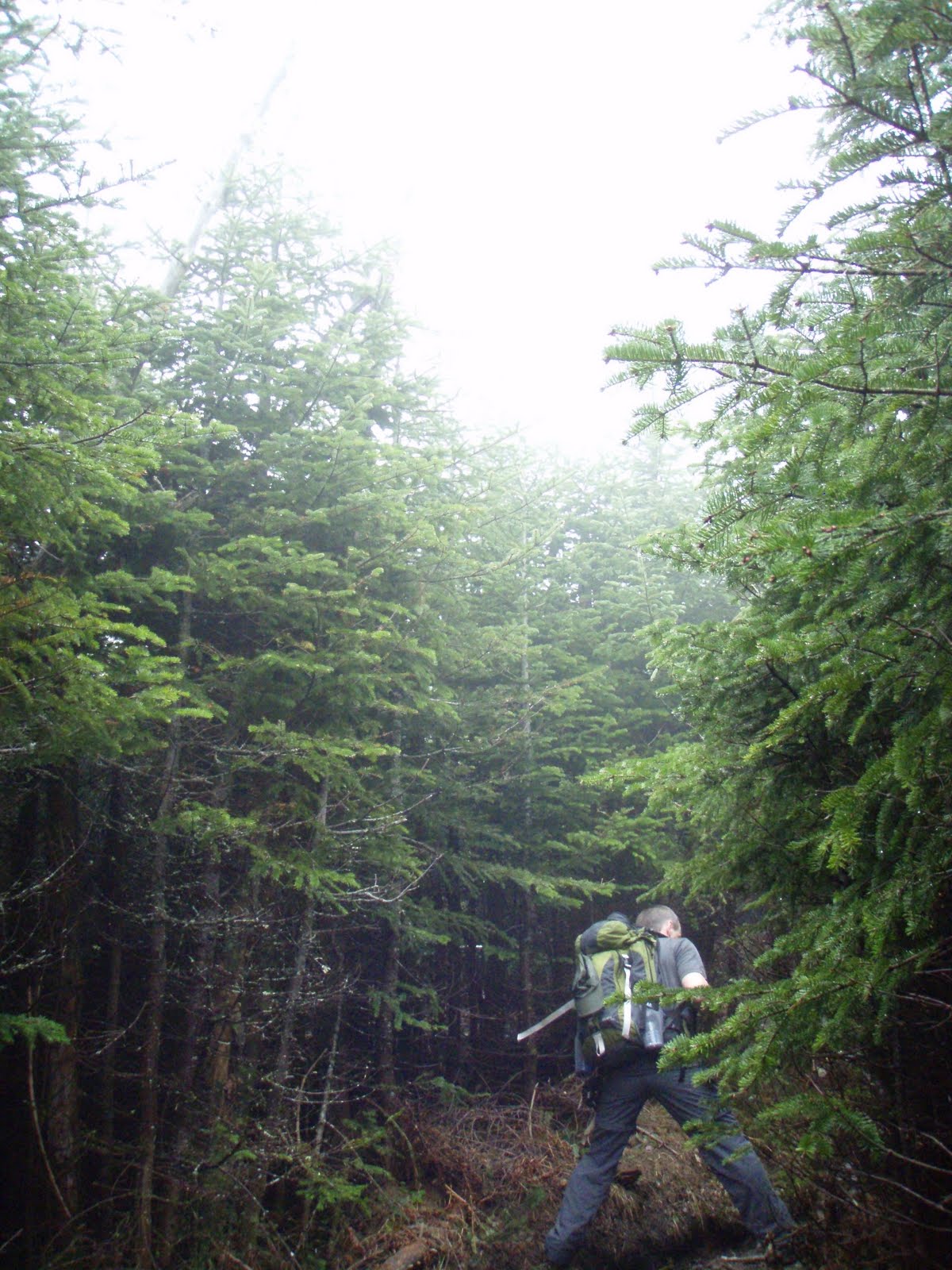
Soon we arrived at Beaver Brook and the 3/4 miles start of nearly continuous cascades! The trail follows the river over steep ledges fitted with steps and re-bar for pulling yourself up. You climb up wet, slippery, broken rock and along side the steep and dangerous brook banking where a slip could be your doom! I could not imagine the campers and through-hikers carrying heavy packs down this trail! It must be so tough!

Still climbing up the steep trail there is plenty of moss and lichen that add to the beauty of this trail. I found some crustose lichen flowering which is not something I had ever seen before. We found a few mushrooms also. Cascades continued, the waters were flowing nicely and it was such a beautiful day. It was getting warm and muggy and it was rather a relief to not have the sun shining down! We stopped and posed for pictures along this exciting trail and amazing world of falling water.

It's one of those areas you could spend all day in taking pictures and taking in the scenery. But just a reminder, extreme caution should be used on this trails and along the bankings which are steep and dangerous. One simple slip and you could be falling down a steep cascade of jagged rock and fast moving water to your death!

Finally we veered away from the brook and passed the trail for the cabin. We started to see people now climbing past us from the cabin and a few descending back to the cabin. Soon we arrived at the Asquam Ridge Trail junction where we straightened out the sign post by wedging in some rocks. From here the trail began to climb rock as it curved around Mt. Blue. There were view spots here and there but the fog was still so thick you could not see beyond a few pine trees.

After climbing for a bit the trail leveled off at a muddy section of trail then began to descend gradually along a ridge. I remembered following a ridge for a short way but did not remember descending and especially not this much. Soon I told Scott it just didn't feel right and I think we missed a trail junction or something. It didn't help that I forgot my map and that I couldn't see anything to get my bearings and it was driving me nuts! Scott reassured me that we were most likely on the trail, that I probably just didn't remember this section. And the fact that people we passed earlier were mentioning the fogged in summit. So this had to be the right way!

Continuing along the muddy ridge we finally got a quick glimpse of Moosilauke's summit cone. YAY! The trail began to climb again and once passing through some washed out sections of trail we passed the Benton trail junction and began to pass people coming down who looked wet and wind blown! A couple hikers told us it was very windy up there. We finally broke tree line at 12:30pm and were greeted with a misty wind blowing at a steady 40mph. It was a mild wind and a welcomed refreshment from the muggy lower portions of the mountain. The sky would light up a little now and then, and a tiny patch of blue/clear sky would open briefly giving a short range view. And like a hiker said, "oh look a view, and poof, there it goes!"

Ah well, as 1HappyHiker commented, sometimes the foggy conditions are just as exciting and interesting! And no one was really complaining, most were enjoying the moment. Not even a group of three from Rhode Island and North Carolina where too bothered by no view. They enjoyed the hike up Beaver Brook so much and rather enjoyed the wind and fog! As we approached the true summit, figures began to appear and as usual the summit area was crowded with a dozen or so hikers. Already having this peak we decided to turn back around a have lunch at the tree line where the wind was lighter.

Sitting there for this short time was so nice. Such a calming atmosphere and no pesky bugs to swish away. Actually there had been no bugs at all, all day! That always makes for a great hike! Once we had our fill we headed back down. We met the group of three again along the shoulder of Mt. Blue and we chatted for a bit. They were a very friendly group! We parted ways and made our usual quick descent, slowing as we began the steep and wet hike down along the brook. Below the cabin we began to pass hikers headed up to the cabin. And now the views began to open up a little better!

Along the trail we spotted a couple Northern/Red Spotted Newts which I moved off trail. Back below the cascades and on level ground, ahhhh, we took notice of the wildflowers again and noticed yellow flowers had since come out which were Trout Lily's. So many neat little wildflowers in this moist woods! We finally dragged our weak and tired legs across the last foot bridge and up to the parking lot, finishing at 3:30pm.

Saturday, May 28, 2011

Moose Mountain East Knob 5/26/11

"More Moose!" (pictures)
(Moose Mountains Facebook Group)

Difficulty: Hard (steep/loose/rocky up Burrows Farm Trail)

Directions: From downtown Farmington, NH take Rt. 153 North into Middleton about 5 miles. Continue onto King's Highway for .9 miles. Turn right at the police station onto Ridge Road. At 1.6 miles turn left onto New Portsmouth Road. Bear left onto New Portsmouth Road Exd. The trail head and kiosk will be seen ahead. You can park at the kiosk or continue 400 feet on an unmaintained road to an upper parking area just past the river.

Report: My third day at Moose Mountains Reservation. I wasn't sure just how much time I would spend as a land steward of this mountain range, but there is so much to see here I will never tire of it! Wildflowers, frogs and so much more! We returned to remove the cable I put over the gate the day before. Apparently it can't be locked because it is a class 6 road. So hopefully it can be locked elsewhere to keep the off road vehicles off the fields and hiking trails! Wendy, a Forester with SPNHF will be giving a tour soon and we will be discussing these things.

Anyhow, once this was done we hiked up New Portsmouth Road passing mud pits from the off road truck use which the Green and Northern Leopard Frogs were enjoying. There were dozens of them! Up to the junction with Burrows Farm Trail which is straight ahead. A left here brings you up to the Burrows Farm Site and field and up to Phoebes Nable Mt. Scott destroyed a fire circle here making sure not to leave a single rock, kicking them down the banking. The trail enters a timber landing zone then climbs passing carpets of violets and patches of pink moccasin flowers.

Once passing a "No Motorized Vehicles" sign the trail began a steep, rocky climb up a slippery, rock filled skid road. The heat and humidity was really killing us but didn't slow us down one bit! We passed a ledgy stream then over some ledgy parts of the trail. Soon we were passing by blue berry bushes and more ledge. Snow Mobile trail markers were present up here. The trail levels off and enters a semi-open plateau of Pitch Pine, Red Pine, Blue Berries, rock erratics and ledges. It was a beautiful area!

The breeze was blowing a welcomed coolness and helped keep the black flies at bay. We found deer and moose tracks as well as some fox scat. We also found a 10 gallon plastic pail chained and locked to a tree and wondered what it was there for. We passed through some high brush and came out with a few ticks, one of which was a deer tick, yuck! We did good all day until we hit the tall brush! Getting late, we had to head back down from here to have a quick dinner and head to work. This hike took about 1.5 hours.

Thursday, May 26, 2011

Moose Mountain Reservation 5/25/11

"Tigers and Leopards and Wildflowers Oh, Yah!" (pictures)
(Moose Mountains Facebook Group)

Difficulty: Easy

Directions: From downtown Farmington, NH take Rt. 153 North into Middleton about 5 miles. Continue onto King's Highway for .9 miles. Turn right at the police station onto Ridge Road. At 1.6 miles turn left onto New Portsmouth Road. Bear left onto New Portsmouth Road Exd. The trail head and kiosk will be seen ahead. You can park at the kiosk or continue 400 feet on an unmaintained road to an upper parking area just past the river.


Report: I returned to Moose Mountains Reservation Wednesday to do some work in the access road culverts and to attach a cable to the gate. It was such a beautiful day! I drove my truck up to the point where a stream crosses the road and parked. I did a quick walk up to the Burrows Farm area to make sure no one was up here in a 4x4 or ATV. Such a wonderful spot. Mountains all around, new leaves on trees a bright green, apple trees flowering and blue sky with white wispy clouds. Ahhhh, so lovely!
I then noticed a bug flying ground level across the dirt. It was an Eastern 6 Spotted Tiger Beetle! I love these florescent green beetles! I returned to the main trail heading back and spotted a couple Northern Leopard Frogs. They are so darn quick and blend right in with the ground cover. I did manage to coax one back out of the leaves for a photo op! Wild Flowers caught my attention again as I traveled along. Yellow Downy Violets and Pink Moccasin flowers where the choice today. Surprisingly after having so many ticks on us the day before I did not have a single one today! Must be they come out later in the day. Or because I was staying away from tall grass, mud and trees!

After getting my hiking, photo fix I then got back to my truck and stopped at each culvert to clean the leaves out and get water flowing again. Black flies began to attack as I affixed a cable over the gate and put up "No Wheeled Vehicle" signage. I kind-of felt bad about blocking this 4x4/ATV paradise, not my thing but every one is different and if that's what they like they should be able to have a place to "play"! But it's not allowed, and even if it was, the property is being abused. I can only hope this doesn't end up being a never ending battle! I don't give up easily and this is a beautiful property needing some TLC, so I am in it for the long haul!

Wednesday, May 25, 2011

Moose Mountain Reservation 5/24/11

"Wildflowers, Mud, Ruts and Ticks" (pictures)
(Moose Mountains Facebook Group)

Difficulty: Easy

Directions: From downtown Farmington, NH take Rt. 153 North into Middleton about 5 miles. Continue onto King's Highway for .9 miles. Turn right at the police station onto Ridge Road. At 1.6 miles turn left onto New Portsmouth Road. Bear left onto New Portsmouth Road Exd. The trail head and kiosk will be seen ahead. You can park at the kiosk or continue 400 feet on an unmaintained road to an upper parking area just past the river.


Report: Recently completing our Land Steward training with the SPNHF I thought we would check on the Moose Mountains Reservation property when Scott got home from work Tuesday. A quick 15 minute drive and we pulled into the parking lot. Someone had put the gate back in place but is still in need of a lock. Wildflowers were out in full force as we walked the road. Black flies were a little bothersome but not all that bad. As we walked the road signs of ATV use was evident worse than when we were here exactly a month ago. Muddy ruts were numerous. As we reached the Cemetery section that passes through private property we noticed the cable had been re-attached and locked across the bridge. Again ATV users had dug up the road along the cemetery and up the field entering the Burrows Farm area.
Once up at the Burrows Farm fields of wild strawberry and grasses were torn up by mud tire tread. It was rather upsetting to see so much disregard to this scenic, historic area. We walked up to what we determined to be the home site and found a boulder with a plaque on it. The apple trees were in bloom and it was such a nice spot. Someone had done target practice on the farm site itself filling some old tin pales up with bullet holes. The over shots had nicked the pine tree that marks one of the corners to the Burrows 1800's cemetery. This got me on a vendetta to do everything in my power to stop the illegal use of this property. To add to all this dismay ticks were racing up our clothing and backs quicker than anything I've ever seen!

Past the field we made our way through muddy ruts and up the RV trail. I rolled a large rock into the large pool of water here for easier crossing and to discourage ATV use across it. We continued to the junction below Phoebes Nable Mt. From here we headed back down the main trail where we erected an old gate across the road that had been thrown in the woods. More ticks and black flies we headed back out and to the truck. We have a lot of work on our hands here. Once we can stop the ATV use on this reservation, trails need to be repaired, foot bridges built, blazing needed and culverts cleaned out! All told Scott had 12 ticks on him in just an hour of hiking and I had 6 on me. YUCK!

Monday, May 23, 2011

SPNHF Moose Mountains Land Steward

MMR Trailhead Sign
(Moose Mountains Facebook Group)
Scott and I just finished taking a two day SPNHF core training coarse to be land stewards of the very large Moose Mountains Reservation in Middleton and Brookfield, NH! Comprising of 2,325 acres and three mountain ranges Moose Mountains Reservation is one of the largest non-developed forests in Southern New Hampshire! It is a crucial tract of land, harboring important headwaters of the Salmon Falls River.  For directions to MMR see my trip report HERE.

Phoebes Nable Spur Trail
The forests and hills contain a host of native wildlife such as black bear, moose and a heron rookery. Hiking, bird watching, hunting, snowmobiling and other low impact outdoor recreation can be enjoyed on the property. With more than 8 miles of woods roads and foot paths, several ponds and marshes, open summit peaks and ledges, early 1800's cemeteries an farmland there is plenty to explore! The Forest Society will work to retain public use for recreation and to protect the properties water shed and natural resources including sustainable forestry or harvesting.

Since the term harvesting and the sheer thought or even sight of logging makes you quiver, as it did us. It is important to understand what SUSTAINABLE Forestry is! It is defined as such: "The stewardship and use of forests and forest lands in a way, and at a rate, that maintains their biodiversity, productivity, regeneration capacity, vitality and their potential to fulfill, now and in the future, relevant ecological, economic and social functions, at local, national, and global levels, and that does not cause damage to other ecosystems." Thus our States economic value in it's vast and lush forests are an important piece of our way of life, as is the pride we have of our natural and untouched woods, mountains and ponds. These aspects are all kept in balance for the future generations to benefit and enjoy from! You can learn more by joining the Forest Society on a tour of an active timber harvest. Meet logging contractors and Consulting Foresters; learn about sustainable forest management in relation to improving timber quality, wildlife habitat, and recreation; and get the latest news about logging practices, equipment, wood products, and the timber markets where products are shipped and sold. Check there field trip page for these tours.

Phoebes Nable Summit
Where do we come into play? It is our job as volunteer land stewards to be the caretakers and ambassadors of this forest. Our responsibilities are numerous from picking up trash, monitoring property lines, marking/building/maintaining hiking trails, watching for illegal uses, assisting in sustainable tree harvesting and speaking to land abuttors. Trails on this property are in need of signs and marking and that will be our main focus over the next two years as we explore the vast forest ourselves, learning the features and finding the best suitable paths to those features. We look forward to be able to care for such a large tract of land so close to home! While sustainable tree harvesting is an important part of these forests for our economy and the future, it is our primary goal to retain and improve the recreational, scenic and natural benefits of this Reservation. These aspects of SPNHF land are all weighed in harmony as necessary parts on a balanced scale.

New Portsmouth Road Trail
Society for the Protection of New Hampshire Forests "envisions a living landscape where managed woodlands, farms and wild lands are woven into the fabric of community life. We envision people caring for lands that sustain dynamic communities with clean water and air, forest and agricultural products, habitat for native plants and animals, scenic beauty, good jobs, and recreational opportunities."

Check the SPNHF Blog for a post on the 2011 Land Steward Class!

Monday, May 16, 2011

A drive around the White Mountains!

(pictures)

A weekend of rain in the forecast Scott and I thought we would just take a casual drive up to the Pinkham Notch Visitor Center and get our WMNF Parking stickers for the year and browse the books and what not. This done we drove around and up Crawford Notch where we stopped at Silver Cascade then over and down Franconia Notch.


We stopped at the Old Man viewing park as I wanted to see if the new Profilers were open to the public during construction. I was excited to see that they were and got to see the "new" Old Man of the Mountain! It was an exciting thing to see and I am glad this park is getting a MUCH needed face lift...get it! Thanks to all those making this place into what's going to be a wonderful place to remember our states great stone profile! Check out this video of the park plans! Video

Stonehouse Pond 5/13/11

"1, 2, 3" (pictures)

Directions: From the Epsom, NH traffic circle take Rt. 202 East/Franklin Pierce Highway 11.3 miles into Northwood. Turn left onto Rt. 9 East/Franklin Pierce Highway and follow 3 miles. At a white house on a sharp corner turn right onto Stonehouse Pond Road (dirt/gate) and follow it .3 miles to a small parking area.

Difficulty: Easy/Moderate

Report: Nothing about this day was frightening or otherwise gory. Yes, it was Friday the 13nth and yes my name is Jason .... and I don't own a chain saw! Scott and I did a walk around Stonehouse Pond on Monday 5/9. There were a bunch of fly fishers there and a large group of rock climbers. I unfortunately didn't have my camera with me. Today my mother was up from Georgia for a months visit and I had been wanting to bring her to this lovely spot. So we made the loop around the pond. The wind was blowing a cool breeze keeping the black flies away. Three set's of fly fishers were seen, one pair bringing there boat ashore, the other out in the pond and another who showed up on the waters as we descended the ledge. Always a great little hike :)

Tuesday, May 10, 2011

NEW NH State Park License Plate!

Do you frequent NH's State Parks? Want free parking for a year? Do you want to support these parks? Now available, NH State Park License Plates! Still want your "Moose" plate? Get the State Park/Moose combo plate! Help NH preserve and protect it's parks and heritage! Available NOW at your nearest DMV, available at town clerk offices at the end of MAY!
FAQ's

Ticks to be worse in NH this season!

Check-it or Tick-et!

Ticks...they quietly sneak up your leg and back. They crawl across your skin, climbing your clothing and finding their way to your head and digging in to make your scalp there family home! Gross huh!? These tiny, flat bodied creeps don't just give you the itchy, creepy crawly's but also cause Lyme disease. Lyme is a serious disease causing a host of brain/head disorders and muscle/joint problems.

Prevent it! Be SURE to check yourself during and after hiking or walking in the woods, grass areas or really whenever you step outside for any activity. A quick check by a friend is best but at the very least do a self visual check and feel around your back, neck and head for those areas you can't see. Something so simple and quick can help you prevent a tick bite. Bug spray is always important as well as long clothing. Be sure to visit the links in this post to inform yourself about ticks and the symptoms of Lyme. It is very important to identify Lyme sooner than later to begin treatment of the disease.

http://www.wmur.com/health/27830397/detail.html

Monday, May 2, 2011

Chocorua's 3 Sisters 4/30/11

"A Spring Mosaic of Color" (pictures)

Difficulty: Hard/Expert (Piper trail is the easier and well maintained trail requiring some rock scrambling. Carter Ledge trail is steep and difficult with loose gravel pitches, rock scrambling and spots where climbing is required on steep granite ledges and cliff faces.)

Directions: From Rt. 28 and Rt. 16 Junction in Ossipee take Rt. 16 (White Mountain Highway) North for 16 miles. Turn left onto Moulton Drive next to a currently closed gift store (Brown Sign will read "Piper Trail". Continue shortly a few hundred feet and fork right at a private residence to a large parking lot. Parking is $3.00 unless you display a seasonal pass.

Report: Oh what a picture perfect day! With the last day of April looking really nice we were all psyched up to get up early and get a decent day hike in. Chocorua was the first from Scott's mouth and though I considered others peaks I finally agreed. Conditions were probably still yucky up North and Chocorua and it's Sister peaks and ledges never disappoint us. We arrived at the parking lot already piling up with 8 or so cars! Sky's were mostly sunny and temps already at a comfortable 60 degrees!

We began our hike at 8:30am on Piper Trail. Like always it felt great to be out in the fresh air amidst the forest! But today felt all the better. We were excited for the upcoming hiking season and all the White Mountains of NH has in hold for us! Better yet not a single black fly was to be seen!! We noted recently logged woods just across the small stream that runs along the trail. Further up we took a break after the long climb up the sandy banking/ridge and were passed by an older couple who started out the same time as us. They continued on Piper trail as most do and we took a right onto the Nickerson Ledge trail.

A short steep climb up to the grown in ledge (side trail on right) we passed the small boulder erratics and continued a gradual climb through beautiful pine forests. After making a steep climb up a loose, gravelly banking we began to cross over granite outcrops. Be sure to take a sharp right at the sandy rock slide. Soon ledges will open up ahead and you walk out onto a granite paradise dotted with jack pines. It never ceases to amaze me how quite this area is. So many people pass this trail by, headed for Chocorua's summit.

The colors right now are so amazing! A mosaic of color. Shades of grey, blue, white, tan and black in the ledges. Green, yellow, grey and brown of the pine trees. Light and dark red of new Spring growth on hardwoods and the shrub outcrops. The blue sky dotted, scraped and muddled with white clouds. The many greens, blues, greys and  reds of the thousands of lichen and moss dotting the granite and tree bark. White and shiny blotches of snow and ice in the granite crevices on Chocorua's impressive granite spire jutting up from the valley below it. Such a beautiful sight to behold!

After a welcomed lunch break to eat and take in the majestic wonder before us we returned to our ascent. After passing a whitish, almost circular rock erratic to the right (which I call Carter Rock) the trail descends slightly to a small col. Here the water from melting snow gathered to a large, deep pond taking over a large section of trail. We bushwacked around fairly easily then began the most difficult part of the trip. Here you begin several rock scrambles some of which require walking along steep sided ledges and climbing over granite ledges. I always forget just how tough this trail is. But very exciting and beautiful and well worth the effort if you can handle such conditions. Snow was still deep along the base of the ledges and along certain cool/wet areas, but nothing all that difficult to manage through.

Once over these ledges the trail snakes through granite and pines and slowly climbs up to the Middle Sister peak. Glimpses of snow speckled Mt. Washington were seen with occasional breaks in the clouds that surrounded NH's highest peak. We arrived at the former Fire Tower at 12:18pm. It was a bit windy and cool here so after some pictures we continued around the corner to a sheltered ledge and sat to have lunch. Chocorua jutted up to our left, the Sandwich range beyond to the West and the many peaks and ridges sprawled out to the North up to Mt. Washington. Such a perfect day!

Although I didn't want to leave this spot it was time to make our descent. We followed the trail across more ledge down to another col. then back up to the 1st Sister peak, then back down to another col. where we took a left onto Piper Trail. We passed several other hikers along this area as usual. We didn't bother with a Chocorua summit today. Our biggest hike in a while we felt it best to avoid the crowded summit and take our time going down. Besides, as I have said before, the view from Middle Sister is almost as good as Chocorua and the ledges on Carter and Piper trails are far more picturesque.

We slowly made our climb down various ledges and snow/ice spots with views of Chocorua slowly diminishing the lower we dropped. Once back in the trees our pace picked up and we made good time making it down the always pleasurable Piper trail.We reached the parking lot around 3:30pm. A wonderful, well spent 7 hours on one of NH's most beautiful mountains! Not one single black fly bothered us!! Temps held steady in the low 60's and winds stayed light to moderate. We moved about half-a-dozen or so blow downs off the trail, a couple remain that need to be axed/sawed. Love, love, love this loop hike!